Member Stu took the time again to put together yet another Trivia Challange. It contains the questions and answers. This is Part Two. Have fun and Good Luck!
Q. What is the primary difference between a Class C control zone and a Class D control zone in Canada?
A. The Class C control zone requires a Mode C transponder unless otherwise cleared by ATC.
Q. What does NDB stand for, and which instrument is used to read it?
A. Non-directional beacon, detected by the ADF, or automatic direction finder.
Q. What does VOR stand for, and which instrument is used to read it?
A. VHF omni-directional range, detected by the VOR receiver and/or the HSI or horizontal situation indicator.
Q. What is the frequency range of VHF radios used in aviation?
A. 118.0 MHz to 136.975 MHz.
Q. There are seven different classes of airspace in Canada. What are they?
A. Class A, B, C, D, E, F, and G.
Q. Which class of airspace in Canada is always uncontrolled?
A. Class G
Q. Which class of airspace in Canada will have a designation of restricted?
A. Class F.
Q. An uncontrolled airport such as Indus or Carstairs-Bishell will have an ATF published in the Canada Flight Supplement. What does ATF stand for, and under which heading is it found?
A. It stands for aerodrome traffic frequency, found under the COMM heading.
Q. What is the normal radius from the centre of an uncontrolled airport where the ATF should be monitored and used?
A. 5 nautical mile
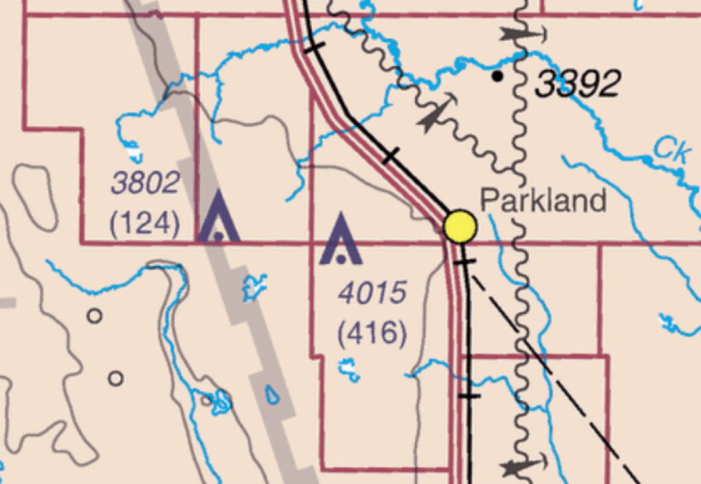
Q. Towers are depicted on a chart as upward pointed arrowheads with a dot at the bottom. They’re also accompanied by two numbers. What do those numbers mean?
A. The top number indicates the tower top height above sea level, the number in brackets indicates the tower height above ground level.
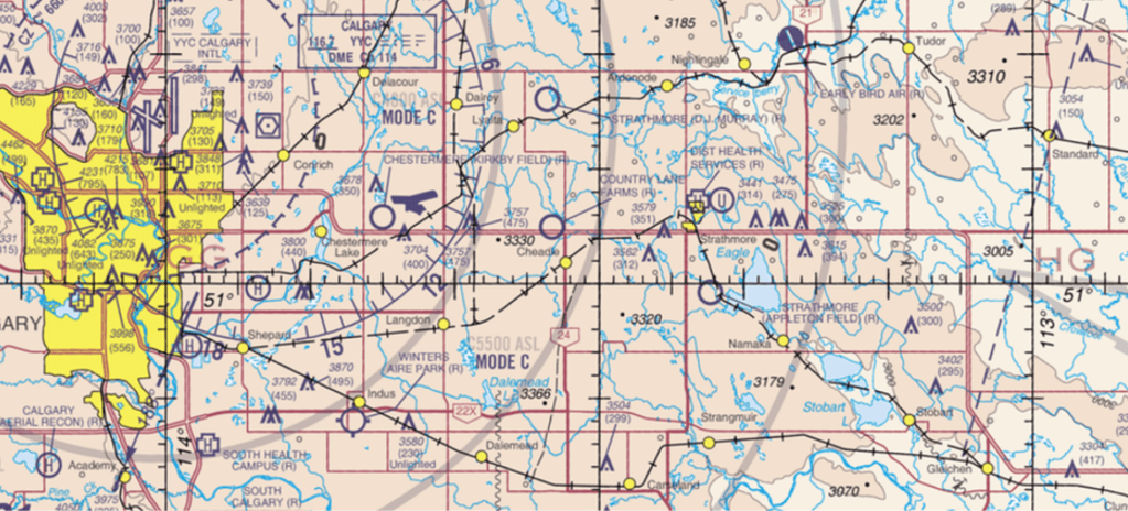
Q. Using the chart section shown above, what are the approximate latitude and longitude locations of Chestermere-Kirkby Field, and Indus Winters Aire Park?
A. CFX8 – N51 02’ 30” W113 45’ 06” CFY4-N50 54’ W113 47.
Q. The latitude and longitude lines shown on the chart section feature tick marks. What distance do these tick marks denote?
A. For the longitude lines running north and south, the tick marks denote one nautical mile of distance. For the latitude lines running east and west, the distance between the tick marks will vary depending on their distance from the equator or North Pole. The distance will become smaller closer to the North Pole, and grow to 1 nautical mile at the equator.
Q. What northern latitude line is half way between the equator and the North Pole? A. 45 degrees north. Q. The word radar is now a commonly used word. What do the letters stand for?
A. Radio detecting and ranging.
Q. What do the letters in ADS-B stand for?
A. Automatic Dependent Surveillance – Broadcast. Q. Used widely for navigation, what does GNSS stand for? A. Global navigation satellite system, commonly known as GPS or global positioning system.
Q. When flying in mountainous areas where strong winds aloft are present, what type of clouds are frequently seen at high altitudes?
A. Lenticular, or lens shaped clouds.
Q. What type of clouds, often compared to cotton balls, are sometimes seen at low to middle altitudes on warm, calm days?
A. Cumulus clouds.
Q. What are the thin wispy clouds that occupy high altitudes and are often spawned by jet contrails?
A. Cirrus clouds.
Q. What is the primary difference between a Cessna 150 and a Cessna 152?
A. The 150 uses a Continental O-200 engine of 100hp, while the 152 uses a Lycoming O-235 of 110hp.
Q. In the Canada Flight Supplement, what does PPR mean?
A. Prior permission required to use the airport.
Q. What device is used by pilots to determine the rough wind speed and direction at an uncontrolled airport?
A. Windsock.
Q. Due to vibrational issues, what is the maximum propeller diameter permitted on a Continental O-200 engine?
A. 69 inches.