Aside from our basic skill set for actually operating and flying our airplanes, just as important are our decision making abilities. That covers everything from when to make a simple radio call to choosing whether or not to fly at all on a particular day.
Having said that, I want to know what you think of a decision I once made, and what you’d have done in the same situation. This wasn’t a major life changing choice, or a dangerous do-or-die scenario. It was nothing dramatic at all, but there was a chance that it could have mattered. It’s about a minor routing change during a mountain flight.
I’ll explain.
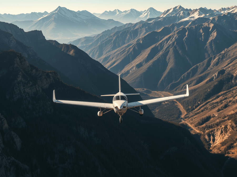
A few years ago on a fine September morning I was flying my Cavalier to the Fairmont Hot Springs airport in the Columbia Valley in BC. The locals there were hosting a fly-in breakfast and I wanted pancakes. I was flying alone, expecting to meet Gerry Macdonald and Barry Wood there, and hopefully some other friends. Pancakes are always better with friends.
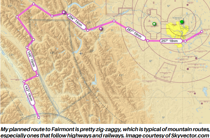
I dutifully filed a detailed flight plan and took off from Kirkby Field. My route from Kirkby’s was a pretty safe one. I flew around the south end of Calgary and Spingbank and picked up the TransCanada Highway. I followed that through the Bow Valley and turned to track Highway 93 from Castle Junction. It goes over the Divide at the Vermillion Pass and into the Vermillion Valley to the Kootenay Pass and a spot known as Kootenay Crossing. From Kootenay Crossing I’d continue south along the highway to scoot west through the pass that leads into the Columbia Valley at Radium. It’s just a few more minutes south from there to Fairmont.
So, here’s where the dilemma arose. When I got to Kootenay Crossing, as noted, I planned to continue south along the highway. But when I looked ahead to the southwest I spotted a low saddle through the western ridge of the valley. It empties out to Highway 95 in the Columbia Valley between a couple of hamlets called Briscoe and Edgewater. The highest spotis about 6000’ ASL and I was at 8500’.
I really wanted to take that route, so I weighed all the options and potential consequences and made my decision. But before I tell you what route I chose, I’ll share my decision making process.
You’ll see that I planned for the worst case scenario of a forced landing in mountainous terrain.
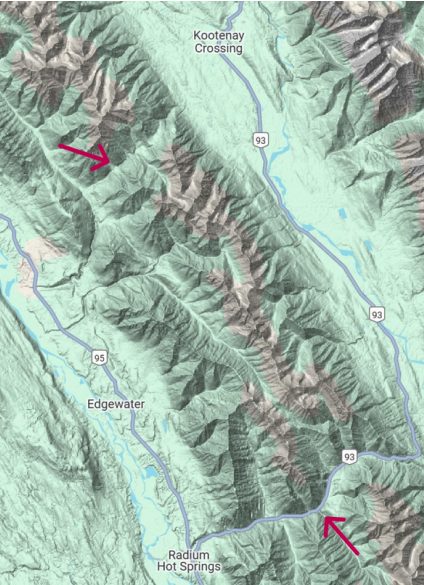
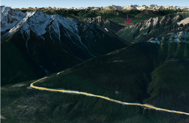
Two potential routes into the Columbia Valley from Kootenay Crossing. The top arrow shows the saddle southwest of Kootenay Crossing. The bottom arrow shows the highway’s path between the Kootenay and Columbia valleys. The highpoint of the highway is 1500 feet lower than the saddle to the north, making the pass deeper and more steeply sloped. Image courtesy of GoogleMaps.
While I know I could have easily just gone over top of everything, I much prefer to follow roads and valleys in the mountains because it drastically improves my odds of location and rescue if there’s a forced landing, and it makes it much safer for search and rescue personnel who respond.
The Pros and Cons
- Pro: The pass looked very inviting with some beautiful scenery and covered a bit of territory that I hadn’t flown over before.
- Con: It would be a deviation from my flight plan.
- Pro: It would only be a minor deviation, and if I was forced down there was some reasonably hospitable territory where it could happen, including logging roads, gentler slopes, and a wide pass.
- Con: However, it was in mountainous territory, and I know that can definitely make things worse in an emergency.
- Pro: If I flew the deviation, I’d actually be over Highway 95 in the Columbia Valley sooner than if I continued along my planned route. The Columbia Valley has much flatter and more open terrain, and easier radio access to RCOs (remote communication outlets) than does the Kootenay Valley which sits in a national park. The Kootenay Valley has plenty of stretches with no cell phone coverage on the ground, and much less open terrain in the event of a forced landing.
- Con: I’d be deviating from my flight plan and if I was faced with a forced landing, searchers would start looking first along my flight planned route.
- Pro: I had a working SPOT locator beacon that would help tremendously for locating me if I was forced down anywhere. Note that at the time I had a 121.5 MHz ELT which I carried by regulation but that I completely discounted as a useful tool for any rescue activity.
- Con: Deviating would add a couple of miles and perhaps a minute to my total flight time. Honestly, not much to worry about there.
- Pro: I would avoid the narrower, deeper pass between the Kootenay Valley and Radium. Honestly, that’s the most hazardous terrain to traverse on this route. The odds of a successful a forced landing and subsequent rescue there are diminished due to the steeper, more heavily treed terrain.
- Pro: The Cav was running beautifully that morning, as usual, and I had no immediate concerns about my engine’s health.
- Con: I know full well that an engine can fail, however the odds of the Cav’s O320 coming apart on me in the next few minutes were very, very low.
- Pro: My deviation would have me off my planned route for only about twelve minutes. And if something did go wrong, I’d be over much more friendly terrain with more options, better comms, and much easier access to rescue services than if I was over the Kootenay Valley.
- Con: Once again, I’d be deviating from my flight plan without informing flight services. That’s because I couldn’t reach either the Invermere or Golden RCOs from my position and altitude as they both sit low in the Columbia Valley and were blocked to me by terrain.
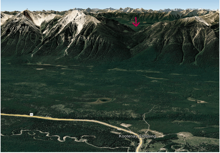
Here’s the view at 8500’ looking southwest into thepass where Highway 93 leaves the Kootenay Valley into the Columbia Valley at Radium, shownby the arrow. Image Courtesy of Google Earth.
So, after weighing all the options I chose to make my deviation, to fly straight from Kootenay Crossing to the saddle directly ahead and into the Columbia Valley. I felt the odds were very much in my favour, and that if something did go wrong making the deviation would actually improve my situation compared to staying over the Kootenay Valley.
Once I got to the Columbia Valley I didn’t bother with a radio call to amend my flight plan because by the time I had that task completed, I’d be back on my planned route over Radium.
So, what do you think? Was my choice a good one, or bad? It was inconsequential in the end since nothing went wrong, but should I have stuck to my original plan? Was the deviation minor enough that it really didn’t matter, or did it have a high potential to cause a great deal of grief for me and search responders had I gone down?
What would you do?
Please consider sharing your response, anonymously if you like, with other Skywriter readers by submitting it to Greg LaBine via e-mail at: crufcnews@gmail.com
