
I’ve been looking for opportunities to build flying hours but I’m starting to run out of places to go. When Stu mentioned in early November that he needed someone to ferry a Zenair CH250 to Reno, Nevada, I was all in. What an adventure that would be, especially in November!
Why Reno? Stu was selling the CH250 for Bashar Hussein. I was the logical choice because I have my own Zenair CH250. However, the Reno deal fell through just as I was packing my bags.
Fortunately, Stu had another buyer waiting in the wings. He was from Castlegar, BC, and he actually showed up with money. The deal was done. The buyer, Poul, was a pretty experienced pilot, but had no tail-wheel time. Thus, it wasn’t at all practical for him to fly it home. So all we had to do was to get the plane to Nelson, about 22 miles north of Castlegar, where Poul would be keeping the plane.
Winter isn’t usually the best time to fly into BC, especially the southern interior region, which gets a LOT of cloud and precipitation in winter. However, we kept our fingers crossed that we’d find a day that would work. And we didn’t need much, either. The flight to Nelson would only take about 2.5 hours at CH250 speeds. The difficulty lay in the ever shortening daylight of November, and the quickly changing mountain winter weather.
To execute this trip I packed the winter survival kit I keep in my CH250. I bring enough food and water for two days, warm winter clothes, sterno and fire starter, flares, blankets and warm boots (I fly in running shoes). I had a backup handheld radio, two GPS’s, iPad, paper maps, two rolls of toilet paper, and an extra large coffee to stay warm in case the airplane’s heater didn’t work. (It worked well by the way).
Normally I’d consider going high and going direct, but this wasn’t a plane I was recently familiar with. Both Stu and I thought that flying near highways would be the better, safer choice.
Stu suggested following Highway 22 to the Crowsnest Pass, then basically tracking Highway 3 the rest of the way, even though the road significantly zig zags, through the region. We did plan a few shortcuts, though. The first was to bypass Sparwood and go direct from the Crowsnest to Fernie, fly over the Fernie ski hill, and pop out over the highway again by Galloway. There’s a secondary highway to follow from the Crowsnest to Fernie, so I felt this was a fairly safe shortcut. The other shortcuts depended on being able to fly high enough to safely cut the corners on a few places where the highway makes those big zigs and zags north and south.
Stu planned to drive out to Nelson and I’d ride back with him. He’d get a head start early in the morning, and thus could text me the actual weather along the route.
Our first opportunity came on November 20th. The forecast was looking really good except for some early morning ground fog. Stu actually started out driving the day before, intending to stay with his folks in Castlegar. I got airborne at about 10 o’clock the morning of the 20th when the mountain valley fog was forecast to be gone. The weather conditions were good and showing improvement, and the forecast looked good so I was hoping we’d have success.
The first leg down Highway 22 to Cowley went very smoothly in a clear sky. I got some great pictures. Stu, who’d elected to stay in Cranbrook overnight, was on the road ahead of me. But he was reporting an overcast layer at about 6500’ between Moyie Lake and Creston. It would still give me about 2500 or 3000 feet between the clouds and the valley floor. With that information I decided to fly at 10,500’ over Fernie and then drop down until I got to Creston.
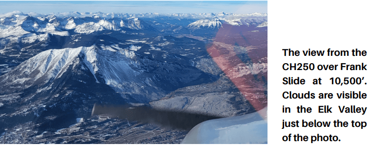
By the time I reached Highway 3 at the Frank Slide I’d climbed to 10,500’ and I could see the path to bypass Sparwood direct to Fernie, but not at 10,500. From my vantage point, it appeared the Elk Valley, where Fernie and Sparwood sit, was closed in with cloud. But what would look like when I got there?
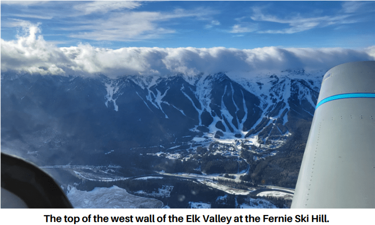
Continuing through the Crowsnest toward Sparwood, I right away realized I was going to have to get back down to get under the clouds. I started down to 8500’. By the time I got to 8500’ I knew I’d need to be at 6500’. I turned the corner into the Elk Valley toward Fernie and saw a shallow but solid wall of cloud sitting atop the mountains that form the west side of the valley. I continued south along the valley, descending further in order to hopefully slip beneath the cloud and make it into the Columbia Valley at Elko.
When I reached the south end of the valley, where it veers sharply west, I was down to almost 5000’ and I couldn’t see around the corner through to Elko. I had two choices. I could continue on, hoping I didn’t go IFR in the last few miles of the narrow westbound part of the valley, or I could turn around while I was still in the really wide portion of the north-south part of it.
The amount of red terrain on the Garmin 496 display cemented my decision to turn back and try another day.
I texted my plight to Stu as I made my way north back toward Sparwood and the Crowsnest Pass. I made a quick stop in Pincher Creek to check fuel (I still had lots), file a new flight plan to home, and text Stu to say I was on my way back to Kirkby’s.
A few days later we were watching the weather and we decided Friday the 24th once again looked really good all the way through to Nelson. Lots of big H’s on the GFA and no colored areas anywhere I wanted to fly. Stu started driving very early Friday morning and I was back in the air again at 10:30 with a fresh coffee and a fresh flight plan. Gary Abel was at home following my SPOT and sending me weather camera pics.
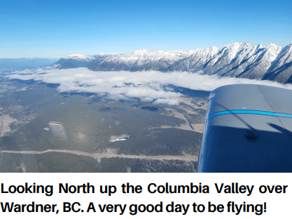
This trip was much better all the way through. There was virtually no cloud and I was able to pop over Fernie and head towards Cranbrook. There was a pretty solid layer of cloud just south of Cranbrook toward Moyie Lake, so I put in a bit of trim down and I started a descent to 6500 at 160 KTS. The cloud layer was very short lived and before I knew it I had clear sailing to the Kootenay Valley at Creston.
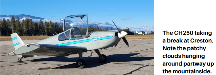
By this time I needed a new coffee and I was ahead of Stu, so I decided to land in Creston, top up the fuel, and check the weather for the last leg. Gary Abel sent me a picture of the plane from the airport camera. I used 47 litres in 1.7 hours of flying so the fuel burn was right on target. The terminal building in Creston looks like a hotel lobby. It’s extremely clean, the bathroom is very well maintained, and Stu’s Cavalier graces the magazine cover at the top of the pile in the pilots lounge. I think Stu probably put it there.
There were a couple of options for how to fly the last leg to Nelson. I could fly north up the Kootenay Lake and turn west down the Slocan Valley, which would put me into Nelson about 22 miles later. Or, I could continue west along Highway 3 over the Kootenay Pass to Castlegar. From there it’s north up the Slocan Valley, again for another 22 miles to Nelson. We decided Castlegar would be the better choice even though I’d have to fly a bit higher.
It was clear beneath a thin, patchy cloud layer, and the Castlegar airport came into view right on schedule. I did my radio calls, headed north up the Slocan Valley, and within a few minutes Nelson airport appeared around the corner. It’s a very tight airport to get into but I did an extended downwind for runway 22, dodged the hotel near the threshold, and did a pretty decent landing.

Poul was there with a few friends so I shut down and got my stuff unloaded. I was ahead of Stu so I was able to give the new owner and a couple of friends each a quick ride, demonstrate how to do a really bad landing for each of them, and get the plane parked, all before it got dark.

This is definitely one of my more memorable flights. I flew into Nelson years ago in my Rans S12 with Stu and Barry Wood in their planes, and I was really glad to have another chance to go back. With the steep, narrow valley where it sits, the airport is one of the most challenging places that I’ve landed.
Next month I’ll have an article detailing how Stu and I did the flight planning and what preparations are important for a mountain flight in the winter.
