

Day 7
We’d hoped that Keith and Mike could accompany us for part of the distance northward as we continued back toward home, but a look at the weather quickly killed that plan. We had to make tracks if we had any hope of getting through Wyoming this day. The Cav leaving Meadow Lake on a perfect morning with an 8800’ density altitude. That’s Pike’s Peak in the background. By Keith Kirkby.
A large swath of low-level moisture was curving in from the southeast creating up-slope conditions that would bring the clouds down as we tried to cross Wyoming. Our goal was Billings, Montana, but we wisely planned for other options. Good thing, as it turned out.
After saying our heartfelt goodbyes and thank you’s we departed Meadow Lake with 8800 feet of density altitude, and banked around to the north. We angled out to the east to stay clear of Denver’s busy airspace, then turned back northwesterly to shoot for Wheatland-Pfifer Field north of Cheyenne. The morning was one of meteorological perfection. There was no wind, no clouds, unlimited visibility and breathtaking mountain and prairie scenery surrounding us. We even had a tail wind.

We got a nasty surprise at Wheatland Pfifer when we learned they didn’t have any gas for sale. But there were three guys on the field who were minutes from leaving after their morning of flying. They were very friendly and said one of their buddies on the field had his own gas. He might be willing to sell us some. A phone call determined the gas owner would give it to us at five dollars a gallon, cash on the barrel head, a bargain we readily accepted.
Bob put a bunch in the Cherokee and I borrowed fifty bucks from Carl to put five gallons in each side of the Cav. It would easily get us to Douglas, another forty miles north, where there definitely was fuel.
We landed at Douglas a short time later as a thunderstorm encroached from the southeast. After fueling in a light rain, we ate the yummy bag lunches that Deanna so thoughtfully prepared for us, and plotted our next move. We decided to track up the west side of the Big Horn range and make for Worland, or ideally, Billings. But there was a big question mark about how far we could actually get with the weather up that way. It didn’t take us long to find out.
We departed Douglas and turned northwest toward a higher plateau that runs out of the south end of the Bighorns. If we could get over that, we might be able to drop down beyond it into the lower plateau known as the Bighorn Basin. But it was not to be.
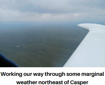
We made it about 45 miles northwest of Douglas and reached a wall of weather hanging right down to the ground. No way we getting through that. We promptly diverted to Casper for the night. It was only about fifteen miles south of us, so it was an easy decision.
Casper’s controller directed us to the Atlantic Aviation ramp where we fueled, tied down and unloaded.
A woman in the FBO named Terry was a true angel as she arranged hotel rooms and the hotel shuttle for us. It was simply outstanding service which we stranded aviators very much appreciated.

Day 8
Today’s goal was to reach home if at all possible. Once again, the weather was the determining factor and early on it wasn’t looking exactly stellar. Low-level clouds and moisture filled the Bighorn Basin to the northwest.
Local weather reports told tales of woe anywhere in that direction. To the northeast the conditions were better, but not by a lot. The numbers were improving slowly, though. And of course, we didn’t need a lot, we just needed enough.
At nine o’clock we made our choice. After checking every weather source we could, we opted to try for Sheridan via the east side of the Bighorns, then round the corner westbound over to Billings.
We departed north-eastbound initially for the Crazy Woman VOR. We soon ran into lower clouds than we expected and veered more easterly to pick our way through lower and more open areas. We made several course changes while scooting through rain showers, following roads and valleys, and dodging around the higher hilltops in the area. It wasn’t pretty, but it was working.
We eventually broke through the really low stuff about 45 miles into the leg. We turned more northwesterly shooting for Sheridan, which was at a lot lower elevation than any other place we’d been in the last three days.
As we traversed the northeast sector of the VOR range we all had our GPS signals drop out. I saw the loss on my Android phone running Fltplan.go, and Bob and Carl had it happen on their Garmins. I think, however, it was actually the GPS receivers for our ADS-B systems that were affected as those are the ones that we’re required to use for ADS-B position data.
We were about eight miles east of Buffalo when Bob got updated weather from Billings. It was now showing 1600’ broken though with good visibility. Billings’ METARs and TAFs had brought good news all morning, and so the deterioration was quite a surprise. Would it close down on us before we got there? I didn’t want to take that chance, so I suggested a safer, though somewhat more distant alternate.
“Bob, I’m worried about Billings getting worse than forecast. What do you guys thing about heading to Miles City, instead?”
It would add about seventy more miles, but at our speeds, and with the favourable winds of the day, that only meant an additional half hour for us. It also meant getting more quickly out of all the weather – we could see that for certain – and into substantially lower terrain.
Bob and Carl talked about it briefly and agreed to the diversion. We turned back to the northeast and punched in KMLS as the destination.
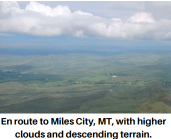
The clouds lifted steadily along our new course, then disappeared almost entirely as we slipped back into Montana and covered the easy 110 NM to Miles City.
The FBO at MLS offers up small bags of nuts and Halloween candy in the pilot lounge, which we very much enjoyed and appreciated.
What we did not appreciate, though, was learning that Lethbridge was no longer open to us to re-enter Canada unless we all had CANPASS privileges. None of us did. So that meant we had to choose another point of entry. We settled reluctantly on Coutts. I say reluctantly because the runway there is little better than a goat trail due to its roughness and abundant gopher holes. I should’ve taken Bob’s advice and selected Del Bonita. I vowed to immediately apply for my CANPASS when we got home.
We left Miles City behind and climbed westward, excited to be getting ever closer to home. We planned one more fuel stop in Montana before crossing the border, and that would be at Shelby, just a few miles east of Cut Bank.

The ride to Shelby seemed long, though it was just a little over two hours. Once again I employed my autopilot to help ease the workload in the afternoon turbulence. The land below was starkly empty featuring coulees, ravines, and barren soils interspersed with patches of grazing land. There were almost no farms or towns and dreadfully few roads. I’d only flown over that region once before and I guess I’d forgotten how much isn’t there.
About 45 minutes into the leg Bob wondered if the winds were any better for us higher aloft. He pulled the Cherokee’s nose up, gaining height toward 8500’. I eased back my throttle and angled gently out to the right to keep him in sight as he worked his way up.
A few minutes later he started back down, disappointed that the currents up there weren’t as helpful as at 6500 or 7000’.
We fueled and peed quickly at Shelby, rushing to make our landing appointment at the border. Bob landed first at Coutts and I followed, wishing like hell we could be at Lethbridge.
The runway was hard to spot and in desperate need of mowing. It was rough and rutted and pockmarked with gopher holes, like landing in a battle zone.
Then we had to wait nearly half an hour on hold for the CBSA people to answer. It beats me why we couldn’t just walk over to the border station to clear.
Okay, one last leg. We’d be home by supper.
I got the Cav light on the wheels as quickly as possible to relieve the jarring effects of the runway. Then it was a matter of staying in ground effect for a few seconds to build speed, and easing into a climbing turn to the north. I spotted Bob and Carl over my right shoulder as the Cherokee charged down the runway, then Bob popped the first notch of flaps and nestled comfortably into the air. His takeoff looked great from my vantage point.
We passed Lethbridge with a tailwind and found Highway 23, which skips past Vulcan. While the weather in deep southern Alberta was excellent, all that changed about 10 miles south of Vulcan. Several thunderstorms spiked the region, tumbling off the Rocks and rolling our way. Bob and Carl checked radar and reported the storms were mostly to the west, but definitely headed our way. Our speed would outpace them, but there was another one somewhere out ahead. Our nice little tailwind had done a 180 on us, now blowing from the north, gusty and belligerent at 20 knots. And with all that, Calgary was reporting three miles visibility in smoke, also with scattered CBs.

We were in our own backyard, of course, which gave us a great advantage. We’d need it, too. Apparently, we were right on the smoke line. The visibility was steadily diminishing to the west, but strangely, off to the east it was well over twenty or thirty miles. Obviously, that was the non-smoking section of the province.
North of Vulcan we were headed straight into a storm cell that, with the poor visibility, I didn’t realize was there. I thought it was merely a shower.
“Stu, that cell ahead is one of the thunderstorms I was talking about earlier,” Bob reported.
“Roger that,” I replied in surprise. “Good catch. Let’s turn more to the west to get around it.”
“Copy, I’ll follow you.”
We caught some rain as we carved around the back side of the storm, but moving west put us more deeply into the smoke. Visibility was dancing around now between two and three miles.
We made it to the Bow River, crossing it at about 4300 feet. Under the circumstances, we agreed to forgo the usual circuit procedures at home, electing instead to do straight-in approaches. I planned to start the approach leg several miles back, just northeast of Indus, paralleling the two roads that bracket Kirkby Field. This would give us familiar landmarks to steer by and help us stabilize the approach in such poor visibility.
I spotted Highway 22 and the familiar curve in the road east of Indus. The new industrial park north of there was my initial fix, being directly in line with Kirkby’s runway. I lined up over the yards, a few hundred metres west of the north-south range road, and reported to Bob that I was slowing down and starting my approach.
One by one, familiar landmarks from the past 32 years slipped into sight, then slipped away, as I advanced on the field. Calgary International reported the wind as 320 at 15 gusting 23. With the steady turbulence I was getting, I believed them.
I dropped the second notch of flaps over Glenmore Trail. A second or two later the runway coalesced into view, a hazy apparition growing clearer every few seconds. A couple of minutes later I passed low over the TransCanada, eased the throttle to idle and sailed into a rather poor and bumpy landing.
I rolled the Cav to the end, then spun around to watch Bob set the Cherokee flawlessly onto the grass. It was just about supper time, and we were home.
In Summary
For anyone interested, these are our actual nav points. You can copy and paste them into your favourite flight planner to see the details.
Routing Points: CFX8 KCTB 465519N1115709W 463824N1114444W KEKS 444253N1112856W 443220N1111843W 442406N1113550W U02 KPIH 421222N1123426W 411359N1141643W 405854N1142106W KENV 404216N1125709W 401707N1124034W KDTA KBVU KINW KSAF 353306N1054722W 353536N1052420W 4V1 KFLY 394904N1041808W KEAN KDGW 430928N1061518W KCPR 432100N1062253W 432818N1061647W 433841N1060455W 442543N1063157W 443907N1063544W KMLS KSBX CEP4 505513N1134449W CFX8
Our route traversed 2712 nautical miles, or 3121 statute miles, which took us about 25 hours of flying time. We were gone for 8 days and flew for 5 ½ of them.
Our flight path was almost the reverse of the one we flew in 2015 when our destination was Tucson, AZ. We flew down the eastern slopes of the Rockies then, went west to Tucson, and returned via Las Vegas, Utah, Idaho and Montana.
Interestingly, the only ground on this trip we hadn’t covered on previous flying adventures was the route between Boulder City and Santa Fe. Oh, and we hadn’t been out to Wendover, either.
The landscapes we saw on this adventure, like the Idaho lava fields, the Utah salt flats, the Grand Canyon, and the absurdly high plateaus of New Mexico and Colorado, are phenomenal treasures not to be forgotten.
We saw again how our planes handle hot and high conditions. They’re pretty damned good at it, and I enjoy having that confidence in the Cav. I know Bob feels the same about the Cherokee.
Some other interesting observations. First, ADS-B is fantastic. I absolutely recommend it, even in Canada. It’s honestly akin to having air-to-air radar in your cockpit, and in the US it’s even better. You can access all sorts of useful data, especially weather, something that’s coming to a few places in Canada, too.
I balked at the price of it when I first got mine, but now I’d be miserable without it. ADS-B is a quantum leap in safety and situational awareness for general aviation pilots.
It’s good to carry tools in your airplane. The key, of course, is how many to carry because they can be heavy. Honestly, I think I carry too many, so I’ll be paring them down. But there’s no doubt of the value in having them when something goes wrong.
CANPASS. I vowed I would apply for mine when I got home and I did. It came within two weeks. That opens up several more possibilities for returning home. I’m sure I’ll enjoy that convenience.
Finally, if you’re at all thinking of flying a cross-country trip, do it. Take the chance. Stretch your wings over the horizon. Put your comfort zone to your rudder. Start small if you like, maybe an overnight out and back. It doesn’t have to be far, but soon you’ll find the farther you go, the better it gets. Then when you’re home again with your plane tucked back into your hangar, all the sights and experiences, all the memories, all the pure adventure of it will have you glowing for weeks.
And you’ll have a great story to tell. I know I’ll want to hear it.

Blue Skies
Stu
