
Day 5
That doesn’t look right, I thought, as I stepped onto the airport ramp and gazed at the Cav. Why were the flaps down? I didn’t leave them that way. I soon realized that the wind at some point in the previous 2 ½ days had been strong enough to get in between the top surface of the wing and the flaps, which are split style, and pull them down. I wished I’d pointed my nose the other way or secured the flap lever in the cockpit. My flap system is exceptionally strong, so I wasn’t too concerned, just annoyed at myself.
It was during my preflight inspection I realized something else was wrong. My ailerons were binding just a bit at a certain point in their travel. My heart raced suddenly as I wondered what was wrong and what it could mean for the rest of the trip.
I told Bob and Carl and we launched the investigation. We traced every inch of the aileron control system as best we could. I was under the fuselage peering into an access panel when I discovered the cause. One of the aileron push rod rod-end bearings was slightly bent. This caused the push rod to deviate just enough to rub up against one of the seat support ribs. That meant the wind had slammed my ailerons hard enough to bend the rod-end bearing.

Okay, we’d identified the culprit, now we could devise a solution. The best one was for Bob, who has smaller hands than me, to reach into the access panel beneath the control rods and sand away a couple of millimeters of the rib where the rubbing was happening. This he did at great awkwardness and discomfort, and the binding disappeared. I’m very grateful for his efforts. Since the rod-end bearing was only bent slightly it posed no serious issue for completing the trip. It would, however, require replacement back home.
We were about 2 ½ hours delayed getting out of Boulder City and it showed. The early afternoon thermals began their raucous rituals as we set out southeastward for Winslow, Arizona. After that, we’d make for Santa Fe, New Mexico, for the night.
A few miles into the leg we again spotted an oncoming target on ADS-B. He was only 500 feet below our altitude so I suggested we climb some more, which we did. The other guy closed steadily on us and we watched his icon slip past our left side. But despite our best efforts, once again we never laid eyes on him. A few minutes later, though, Bob spotted an all black UH-60 helicopter pass us below on our right side. We might have had a much closer call with the helicopter had we remained at our previous altitude. The helo was not on ADS-B.
A weak haze layer permeated the sky, courtesy of distant wildfires. It frustrated our efforts to more clearly see the southwest rim of the Grand Canyon. It was a few miles away, but we couldn’t see it quite sharply enough. Even with what we could spot, though, it was far more impressive than I expected. The canyon’s sheer scale and enormity were simply stunning. The airspace above the canyon is understandably heavily regulated, and we were just outside of it, but sadly we lacked the time to deviate any closer for a better look.

The ride to Winslow was rough. It was hot and bumpy. We watched the terrain change below us, slipping away from hardscrabble desert to a mountainous landscape with more alpine trees and higher terrain. As we passed south of Flagstaff’s 7000 foot high airport, Bob talked with the tower controller who warned us of an Embraer RJ departing initially in our direction.
We watched the RJ turn left and away from us in a climbing turn to the northeast. The land after Flagstaff changed back to flat pan desert, much more resistant to erosion than what we saw to the west. By far the most exciting feature there was a giant meteor crater about 15 miles west of Winslow. That was enormously enjoyable for me because I tend to geek out about geography, especially when I can see it from Cavalier altitudes.

The line attendant at Winslow was friendly and informative as we fueled. He explained there were basically only two things of any consequence in the town. One was the railroad. The other was a statue at a downtown intersection of a man with a guitar. It commemorated the Eagles’ hit song “Take it Easy”, written by Jackson Browne and Glenn Frey. The second verse opens with the line, “Well I’m a standin’ on a corner in Winslow, Arizona.” Winslow was also a stop on the old Route 66.
We took off against a gusty wind and banked northwest for another two hour leg to Santa Fe. The desert continued, only now it rose even higher as we encroached on the most southern reaches of the Rocky Mountains. There was a mixture of mountains, hoodoos, sheer cliffs and elevated plateaus. Once into New Mexico, some plateaus leveled off at over 9000’. At one point I saddled an updraft that bucked me to 11,200’ before I started back down, and I was still only 2000’ AGL. The Cav didn’t seem to know the difference, but I did.
Flying above 8500’ feet does one of two things to me. I either get a headache, or I get very dry. This is frustrating since I can’t drink much up there; the Cav doesn’t have a bathroom. As a consolation prize I ate an apple and sipped occasionally at my water bottle.
The Cav’s autopilot was a real bonus on this leg. It cut my workload with the turbulence and helped me stave off fatigue. I don’t normally use it, but on legs like this it’s a treasure.
We neared our destination just before five o’clock. I was a mile or so ahead of the Cherokee when I contacted Santa Fe tower about eight miles back. The controller instructed me to call him entering the zone at five miles out. Bob received the same instruction a moment later.
As we closed on the airport the controller cleared a Cessna Citation for landing on runway 20. I spotted the jet on final north of the field.
“Santa Fe tower,” I radioed, “Experimental Bravo Quebec Romeo five miles back now.”
“Experimental Bravo Quebec Romeo, cleared to land runway two-zero. Traffic is a Citation on final for runway two-zero.”
“Cleared to land runway two-zero, I have the Citation in sight, Bravo Quebec Romeo.”
I turned right base as the Cessna rolled out to the far end of the runway. I dropped my first notch of flaps and trimmed for nose down. Bob called that he was five miles out, and received the same clearance to land with me as his preceding traffic.
My landing was good enough that I don’t recall it being bad and I cleared at the first taxiway. Then I got a surprise as the controller wanted to chat. He asked about our trip, and where we were from. He stated his wife is from Toronto and that they were headed to Vancouver Island in a few weeks.
There was no other traffic but I still felt a bit self-conscious chatting on a tower frequency like that. It was an unexpected and pleasant welcome at the end of a tough, eventful day of aerial adventuring. I taxied to the FBO ramp and shut down just as Bob and Carl rolled up to their spot.
Day 6
This would be a short day of flying for us, a bit less than 250 NM in two legs. Just as I lifted off runway 02 I spotted an F-111 swing-wing fighter on the north ramp. It’s the airport’s gate guard, moved there because its normal spot was under construction. Pretty cool to see that.
We turned a little southeasterly to arc around the bottom of the Sangre de Cristo Mountains, the most southerly range of the Rockies. Even going around the end of the mountains we needed nearly 10,000 feet to stay clear of the terrain. The peaks to the north, of course, were vastly higher. I freely admit that I breathed a sigh of relief as we left the mountains behind us for good and headed toward some flatter, and thus more familiar and comfortable, prairie terrain.
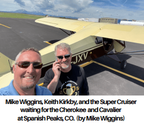
We turned north abeam Las Vegas, New Mexico, and made for a place called Spanish Peaks, just across the state line into Colorado. We’d have a small welcoming party there. Bob’s son Keith lives in Colorado Springs. Keith has longterm use of Bob’s Piper PA-12 Super Cruiser that he hangars at the Meadow Lake airport on the northeast outskirts of the city. Keith and his buddy Mike were en route in the Cruiser to meet us at Spanish Peaks. Then we’d all fly back to Meadow Lake in formation.
In 2017 Bob and Keith flew the Cruiser from Calgary to Gage, Oklahoma, to collect the Starduster biplane Bob bought. I flew alongside in the Cav. On the way back north, Keith and the Cruiser broke off to return to Colorado while Bob and I continued home. I thoroughly enjoyed Keith’s company on that adventure and I very much looked forward to seeing him again.
The eastern slopes of the mountains were stunning in the morning sun. I noted how their appearance began to mimic that of the rest of the Rockies all the way back to Alberta. The flora beneath us glowed brilliantly green, the result of a wet spring. It would soon turn blonde and brown as the grasses and shrubs parched in the typically hot, arid summer. I did notice some pretty big storms building up over the peaks to our north. It was too early to tell if they were heading into our flight path or dumping themselves out on the high rocks.
We were about 30 miles back from Spanish Peaks when my ADS-B showed the Cruiser landing on runway 27. I let Bob know since his system displays a smaller range. As we entered the landing pattern a few minutes later, the Cruiser’s distinct paint scheme gleamed in the morning sun.
I was the last one down and I taxied to the pumps as Bob and Keith reunited. I greeted Keith who then introduced me to Mike. I took an instant liking to him.

With a glance north at the growing weather, we decided to get going again. We launched on 09 with no wind and I was impressed to see the Cruiser climb so well from the 6000’ high runway. It was no doubt a combination of the newly rebuilt engine and the large wing making good use of the growing thermals.
We settled into a loose V formation with Keith and Mike leading. Bob and Carl took the right side and I had the left. Bob told me later that he had a bit of trouble getting the Cherokee configured to comfortably maintain the Cruiser’s speed of about 105 mph. As I did for nearly 1300 miles with the Cruiser in 2017, I simply dropped two notches of flaps and dropped back to 2200 rpm. Piece of cake.
We spent some time positioning for Mike and Keith to shoot pictures and video. It’s solid gold to have photos and video of your plane in flight, especially when it’s during a flying adventure.

I cranked into a hard left 360 to go line astern as Keith led us into the Colorado Springs area. We skirted the main airport’s Class C space and set up for a left downwind for 15 at Meadow Lake, whose ident is KFLY. A storm cell now perched at the west end of the city and was clearly giving it grief, but so far hadn’t extended to our position.
A Piper Pawnee pilot announced himself throughout a right hand circuit, and at one point stated he was on a right base leg for the runway while Bob was on a left base. What I didn’t hear was that the Pawnee was landing on the parallel grass runway whose threshold was half way down the length of the paved runway we were using. It gave me a whole bunch of needless stress.
I rolled in last to stop in front of Keith’s rented hangar, a palatial affair that the Cruiser shares with a Cessna 150. Three minutes after I stepped out of the Cav, the storm’s gust front reached out and touched us. We hastily rolled all three planes inside and out of the storm’s onslaught.
We spent the rest of the afternoon hanging out with Keith and Mike hangar flying and swapping flying stories. I enjoyed hearing how the two of them had flown the Cruiser to Michigan and back, as well as on other shorter adventures. Mike’s a new pilot with just shy of a hundred hours. He’s thoroughly enjoying his aviation journey and the time spent under Keith’s mentorship in the Cruiser.
It was wonderful to see his enthusiasm and their camaraderie and friendship. I hope I get to hear more of where Mike’s flying takes him.
Keith and his wife Deanna generously hosted us for the night and prepared a terrific dinner. We’re very grateful for their exceptional hospitality.
Stu
