Okay, let’s switch,” Bob radioed from his Cherokee. “Rog, switching.” I pressed the frequency flop button on the Cav’s radio and saw the display change to 122.2.”
“One.”
“Two,” I replied tersely.
“Great Falls Radio,” Kirkby called, “This is Cherokee Charlie Foxtrot Xray Yankee Bravo on the Cut Bank RCO.” The radio was silent as we waited, Bob and Carl Forman in Kirkby’s plane, me in my Cavalier.
“Cherokee Foxtrot Xray Yankee Bravo, go ahead.”
“Great Falls Radio, Foxtrot Xray Yankee Bravo, plus one, is approximately 5 miles north of the border at seven thousand five hundred on a trans-border flight plan looking for a transponder code, please.”
“Cherokee Foxtrot Xray Yankee Bravo, you’re with Golf Bravo Quebec Romeo?” the controller asked.
“That’s affirmative”
The controller had us stand by for a moment, then provided our codes. We each tuned our transponders and a couple of minutes later passed over the almost invisible border with the United States. I marveled again, somewhat proudly, that it was the longest open and undefended border in the world.
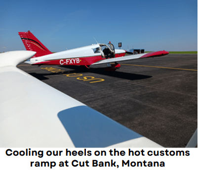
A few minutes later I set the Cav down well behind Kirkby and Forman on Cut Bank’s runway 14, and slowed enough to make the intersection taxiway. We rolled to the customs ramp, shut down, and opened our cockpit doors to stay cool in the warm morning sun as we waited for the customs officers to appear.
Cut Bank is often the first stop on our summer flying adventures. It’s a convenient place to enter the US and then jump off for wherever we’re headed. We’re usually in the air again within half an hour.
This time, though, we sat in our planes for over half an hour waiting for the customs guys to even arrive. When they did show, the processing went extremely slowly as a new guy tried to work his way through the computer system that wasn’t working. His training officer made some calls and eventually managed to get things operational. In the end, we spent an hour and a half at Cut Bank, a delay that would cost us later.
Freshly fueled and happy to be on our way again, we took off and headed south. We flew toward Helena near where we’d angle southeast for Ennis and another fuel stop. Our other option from Helena was to go southwest which would put us in a valley toward Butte and later Dillon along I-15. I went that way in 2019 with Doug Eaglesham and Dennis Fox. But back then we had better weather for it.
As it was, along the Ennis Valley, clouds bottoms menaced the mountain tops and tried to force us lower along our course. We scooted through their damp, drooping tendrils, not really worried because the valley was so wide. Our two planes had lots of room to maneuver should weather become more troublesome. We wondered, though, how far south it stretched. Would it block the Raynolds Pass that sat at 6800 feet?
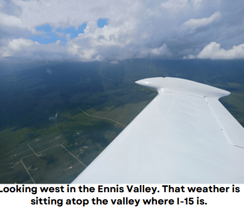
About 35 miles north of Ennis we outran the lower clouds. Relieved, I looked west to see the weather causing havoc in the valley where I-15 sat. We clearly chose well.We fueled and pottied at Ennis, which is incidentally at 45 degrees north latitude, half way to the north pole or the equator, depending on which direction you’re heading.
Now we faced a pretty hot and high takeoff from the 5400’ high runway. Our density altitude worked out to about 7300 feet. Luckily, the pavement is 7600 feet long, so we were unlikely to have any issues.
The Cherokee accelerated along the runway, steadily gaining speed, but using much more ground than normal. Bob eased the Piper gently into the air and held the runway heading, gaining speed before his turn. He later described his takeoff as ‘mushy’.
“Ennis airport traffic,” I called, “Cavalier Bravo Quebec Romeo is rolling runway 34 in sequence. Left turn out southbound from Ennis.” The Cav started forward as I pushed the throttle. My acceleration was good, but nothing like it is back at home. I too eased my plane into the air where it sped up much more slowly than normal. I’d have to get used to this because our route plan was going to take us to a lot of hot and high airports on this adventure.
I caught up to Bob climbing out southbound toward the Raynolds Pass a few miles south. Once we cleared the pass, we turned to the southwest for our final destination of the day, Pocatello, Idaho. But our reaching there was beginning to seem doubtful. Thunderstorms interrupted the horizon in various locations ahead. Some were waning, but more appeared to be growing. This is what worried us during the delay at the border.
The storms were still a long way off and more alternates became viable the closer we got to I-15. We flew along over Idaho’s post-volcanic landscape which included calderas, lava fields, and sand dunes. I was very uncomfortable for the few minutes we spent above the lava. A forced landing there meant certain death on the jagged rock shards.
While we played chicken with the approaching thunderstorms we got to use the weather features on our ADS-B systems for the first time. It was tremendously helpful to see the storms cells on radar, but comparing the ADS-B radar image with what Bob and Carl were able to bring up on Windy.com showed the ADS-B image was a few minutes older than what Windy offered. We were operating in a visual environment, so we could look out the window for the best comparison. I wondered how that might go in an IFR situation.
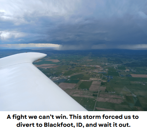
We wound up having to set down at Blackfoot, a town about 20 miles up the road from Pocatello. We cooled our heels and pored over the radar for a bit more than an hour as a big cell battered our destination. Like a school yard bully bored with beating his victim, the storm finally trundled off to the northwest leaving us an unfettered path to our final landing of the day.
Day 2
The morning was delightful. Clear blue skies surrounded us as we prepped our planes. We’d see some great sights today if our plan unfolded as we hoped. After takeoff, Pocatello’s controller cleared us southbound out of his airspace and we switched to our en route frequency.
“How high do you want to go, Stu?” Bob queried.
“How about 7500 feet to start?” I suggested.
“Roger that. I’m going to cruise climb to get there.”
“Copy. Likewise. I’m at your six o’clock for three quarters of a mile.”
We had the Malad City VOR punched in to our GPS’s, though we’d be angling off to the southwest before we got there. We climbed steadily in the calm air enjoying how the sun captured the high valley below us and the mountains to either side. We chatted about various things like the landscape below, ADS-B, and Carl’s new high falutin’ Garmin GPS that he was practicing with in the Cherokee’s right seat.
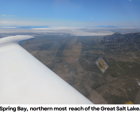
We soon turned more to the right, crossed a high ridge and made for the Lucin VOR in the middle of the desert west of the Great Salt Lake. We were headed for Wendover, a town that sits right on the border of Utah and Nevada. There are casinos on the Nevada side, but not on the Utah side.
The Lucin VOR passed by off our left wings and we were surprised to see there’s actually an airport there in the middle of absolutely nowhere. It’s a dirt strip with a couple of runways in seemingly good condition, and is marked as Restricted on the map. I got curious and learned that the owner’s address comes back to an obscure bay in a shabby looking building shared by a VW repair shop in an industrial area in Long Beach, California.
A Google Earth satellite shot also shows a camouflaged single-engine Cessna in front of the only building on the site. Now, I’m not saying that Lucin might be an airfield used for clandestine governmental activities, I’m just saying what I saw. If you know what I mean.
We needed to be a bit more careful with our navigation now. We were approaching a block of restricted airspace that we needed to circumnavigate to the west to reach Wendover. We continued on around the restricted zone, which was bounded by a small range of mountains, and banked back to the southeast to set up for a long straight-in to runway 08.
We landed, fueled up, and parked our planes. We then spent about 45 minutes exploring the small museum on the field and enjoying the history of the place. I bought a souvenir shirt. I’m grateful that Bob and Carl agreed to accompany me on my dalliance to Wendover.
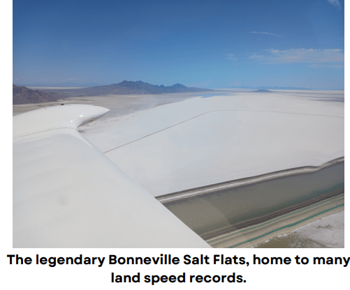
We lit out eastbound, climbing slowly over the bright white salt flats. We flew along a roughly 10 mile wide strip of airspace between the previously mentioned restricted zone to the north and a similar one to the south. We passed just south of the famous Bonneville Salt Flats where a lot of land speed records have been set. That was cool to see, too.
As we leveled off on the south side of the Interstate highway below us, I spotted an aircraft on ADS-B approaching from our 12 o’clock. We adjusted our position a bit more to the right for added clearance, and we increased our altitude. We watched our screens as the other plane got closer, and we all tried our best to spot it as it passed. But we never laid eyes on the guy.
To be fair, we were most likely looking for a white airplane a couple of miles away against a blazing white backdrop. I can see how we might not see it. Or perhaps it was a plane engaged in clandestine governmental activities. If you know what I mean.
We rounded the corner at the east end of the restricted airspace and set up for our next stop, Delta, Utah. We soon passed by the Simpson Mountains, and Carl declared they appeared lonely and sad looking. I thought Carl maybe ought to go back to figuring out his new GPS.
It was definitely getting bumpier in the afternoon heat and it was taking its toll on my forward speed. I was continually falling behind Bob as I was all over the throttle trying to keep my RPMs in the right range. I’d catch a thermal and the engine would surge toward red line, so I pulled the throttle back. In the next instant I was fighting a downdraft that required nose up and increased power. Kirkby’s Cherokee has a constant speed prop, of course, so speed control for him was a piece of cake.
We refueled at Delta and climbed as fast as we could away from the desert heat. Small storm cells were forming ahead of us and we wanted to get past them before they blocked our way for good. We found ourselves near a small squall along our trajectory. It was clearly growing but it didn’t amount to much while we were there. “That one didn’t even get the windshield wet,” Bob lamented. A few minutes later, another building storm did us the courtesy of a brief shower which was enough to clean both our windscreens.
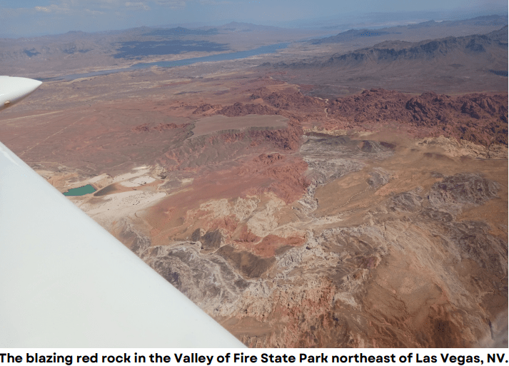
I watched the miles wind down as we left more and more of them behind us. The landscape slowly shifted from one with desert grasses and shrubs to that of almost complete rock and sand. The outcroppings evolved into more rugged and dramatic looking ramparts as we approached the Las Vegas area, especially when we reached the Valley of Fire State Park. There the jagged, iron infused landscape glowed bright red in the falling afternoon sun. The startlingly blue-green waters of Lake Mead, which feeds the Hoover Dam, flowed into sight and we began the set up for our landing at Boulder City.
Boulder City is a small community on the southeastern outskirts of Vegas. Its airport is bordered less than two miles to the north by a small range of sharp mountains. We had a 23 knot southeast wind, which aligned well with BVU’s runway 15. But the upslope wind against the heat soaked southern slopes of the ridge to the north created all sorts of chaos for our approach to the field. On top of that, the runway is sloped downhill to the south at nearly 3%.
Kirkby went first and floated well beyond half the runway length before he touched down. With the ass-kicking I was getting on left base and final, I reckoned that I’d be lucky to not have to go around. Surprisingly, my landing was exquisite, easily the best one of the entire trip. Please don’t think I’m bragging because I have no idea how it happened in those conditions.
We found a spot at the north end of the field and for the next hour saw a terrific array of tactical aircraft doing takeoffs, landings,/ and touch and go’s. We saw a B52 fly over, as well as several F-16s in aggressor squadron colours. There were some F-15s departing, a four-ship flight of F-35s departing, and a four-ship of F-22s taking off. But the best thing was seeing a U-2 departing to the south. It was thrilling to see such a rare, amazing, and iconic airplane in person.
We spent three nights in Vegas as we toured various sights that didn’t involve The Strip or any of the casinos. On one morning we headed out to where we could watch landings and takeoffs at Nellis Air Force Base, just north of the city.
We found a spot at the north end of the field and for the next hour saw a terrific array of tactical aircraft doing takeoffs, landings,/ and touch and go’s. We saw a B52 fly over, as well as several F-16s in aggressor squadron colours. There were some F-15s departing, a four-ship flight of F-35s departing, and a four-ship of F-22s taking off. But the best thing was seeing a U-2 departing to the south. It was thrilling to see such a rare, amazing, and iconic airplane in person.
