
The new owners of my RV-9 had brought the plane down to Eugene, Oregon, in early spring for paint, and they asked if I would take them down to get it. I figured it would be a great trip to test out the eAPIS System and make a stop at Van’s for some goodies. The plane had plenty of hours on it and a few good trips under its wings, so there was no reason not to go. I got all my homework done for crossing the border and agreed to take them down. We kept in touch throughout the month on the plane’s progress to decide when we should make the flight. The date was set for June 19, 2009, and the weather watching began.
We picked a day that looked like the best choice weather-wise. No day looked perfect, so we really did not know if we could make it in.
On Friday morning, I got up at 4 AM in order to get to the airport on time and get into Lethbridge to pick up my passengers. I landed at 6:45 in Lethbridge, and we were wheels up again at 7:25 heading for the border. I set the cruise climb at 700 fpm and let the autopilot do the work. About 5 minutes from the border, I tried to raise Great Falls radio through the Cut Bank RCO. After a few tries, we got a reply. Of course, they did not have our flight plan on file. We confirmed that our flight plan was open with Canadian FSS. They had the same problem with an aircraft ahead of us, so we just air filed a new plan with them. We awaited our transponder code and got it just before the spinner crossed the line.
We flew at 10,500 and looked down at Chief Mountain as we went by. We found a gap in a pass to make our way through, and we were soon on our descent into Kalispell Glacier Park. We were cleared for the left base and soon landed. We met with the CBP and then filled up the plane. The next leg would be a nonstop into Aurora, Oregon, to visit Van’s Aircraft. I placed an order for pick up the day before since I would be passing through the area.

The weather soon deteriorated as we headed west. The Garmin 496’s in-flight weather was a great tool to make sure we kept going toward the best of the weather. We just compared the weather to what we were in and decided from there which way to go. Once we popped into the valley southeast of Sandpoint, we were in a safer position, having more options available. The rain let up just east of Coeur D’Alene, and we requested flight following as our higher altitude allowed us to be on radar. Not far after Spokane, we got pushed down again. We flew between layers (the low layer was scattered) in rain, and we really did not know if continuing on would get us through. I just kept comparing the weather on the 496 and aimed the plane for the smallest stretch of the worst weather. The sky soon started to brighten up, and before long, we were in the clear. A climb to higher altitude was in order.
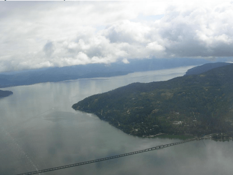
Pasco slid under us, and we just kept getting switched from one center to the next as they pointed out traffic. As we headed west out the Columbia River, the weather started to push us down again. We then knew that a lower altitude flight through the gorge would be required. Visibility was still good as we entered the “tunnel.” Winds were kicking up pretty good, and we got one good hit going through, and the rest was just light turbulence. Halfway through, center lost us on radar and called us immediately to make sure we were OK. Soon after that, they lost radio contact with us and could not advise us of the next frequency change. They relayed with a heavy above, and we switched over. This all happened within a few minutes of each other. They sure look after you when flying down there.
We popped through on the west side and turned southwest bound to Aurora. Map reading out there is really tough. Low level at 200 mph does not help either. I guess that is why I have four GPS screens. The scenery was beautiful as we cruised under a bumpy broken layer. Aurora was soon under our wings, and we touched down three hours from Kalispell after zigzagging our way through with over 20 knots of wind on the nose. I gave Rob Hickman a call when we landed, and he came out for a visit. He is the designer of the Advanced Flight Systems EFIS screens that I have. We had a nice chat, and he answered a few questions that I had. I picked up my stuff and looked for a place to get the plane fueled. We walked over to the Jet Center and found out they served free lunch on Fridays. We had a great lunch while they filled up the plane.
Off on the next leg to Eugene. We tuned Eugene approach, and they pointed out traffic as we cruised south. We had a Cessna Caravan out front that we kept an eye on. Approach gave him 34L with a left-hand circuit and me 34R with a right-hand circuit. Once I got switched to tower, they asked where I was going at the airport and realized that I needed 34L. They then just told me to slide over for the runway instead. The funny part was somewhere in there we overtook the Caravan and slid in front of him. He landed while we were taxing in. Gotta love the RV-10 speed.
We taxied up to Senergy Air, where the boys’ plane was getting painted. It is the RV-9 that I built before the RV-10. We all got out and met several new people. The plane looked awesome, and the boys were really happy to see it in person. The trouble was it was still not quite finished. I had to make sure I gave myself an extra day to get home, so I had to start planning as to when I would head back.
After relaxing for a while, I called FSS for an update on the Portland and the Gorge weather, as the weather was getting worse when we left Aurora. They confirmed that the Gorge was closed in with heavy rain and poor visibility. That confirmed my stay for the night in Eugene. The weather for the morning looked much better, according to them.
We all went out for supper and then went back to file a departure for the eAPIS and book a time with CANPASS. My plan was to make Cranbrook for 11 AM on Saturday and stop in Sandpoint to file a flight plan before the border crossing. I figured if I got airborne by 6 AM, I should make it.
I did not sleep at all that night as I kept waking up and checking the time. I was afraid that the alarm was not going to go off. When it hit 3:30, I figured I had better get up. I got showered up, grabbed something to eat, and called a cab to get me to the airport. I got to the airport before 5:00 AM. I got the plane flight ready and had the fuel truck fill everything, even the tip tanks, for a total of 75 gallons. I would have lots to spare to get home just in case I could not get gas along the way.
I was wheels up at 6:00 AM out of Eugene heading for Sandpoint. I got to a nice cruising altitude and was heading north. I was cleared from Cascade departure and on to Seattle Center. The rain soon started, and I started to descend to stay clear of the cloud. The weather was not on my side. I slid around lots of low-hanging cloud and worked my way north. There were lots of airports around, so if I got stopped, I would just land. I got a bit too low in the hilly country for the radar to track me, so I lost flight following for about 10 minutes. The weather got better near Portland, and there were several balloons in the air. You would not catch those guys flying in the rain around here. I guess it was a good weather day??
As I got ready to head east through the Gorge, they canceled flight following. I guess they knew they would lose me in the Gorge, so there was no point. The ceiling in the Gorge was not as FSS told me. They said 5000 ft overcast. I guess they missed the fact that there was another layer of cloud much lower. I scooted under the deck for a look-see and to make a decision. I knew where the power lines were and had no intention of getting that low. The center of the Gorge had the best ceilings that kept getting better as I headed east. The forecast on the east side of the Cascade was clear and 496 showed the same. The sky started to get much brighter, and it was soon time to get the sunglasses on.
I got clear of the cloud and set the cruise climb for a leveling altitude of 11,500. Mount Adams and Rainier soon came into view. It was spectacular. I got the oxygen on, cranked the tunes, and opened up my juice and muffin for breakfast. It was time for a break after the challenging flight I just had. I switched the transfer pumps on and watched the fuel gauges rise as they pumped fuel into the mains.
I looked ahead at the weather on the 496, and Sandpoint kept changing from IFR to Marginal VFR. It didn’t look like I was going to get in there either. The cloud cover below soon came into view. Spokane was reporting 1200’ scattered. The problem was the terrain around is a bit higher than the field, and I did not know if I could get down into Sandpoint. From my vantage point, the layer was not scattered. I got clearance to drop down and enjoyed the beautiful scenery passing by. I overflew the Spokane airport and continued up the valley to Sandpoint. Approach kept pointing out aircraft to me, and one comment was that I was “overtaking the aircraft by a whole bunch.” Not sure if that was a professional term, but she giggled as she said it. At the time, I was pushing it a bit and was grounding at 190 knots through the area to make time.
The Spokane area did turn out to be scattered, so I opted to climb up to see if I could poke into Sandpoint. I figured it would be clear over the lake, and getting in would work. The lake soon came into view, and the weather was fine for landing. I pulled up to the pumps for the last chance for cheap gas after a 2.6 hr flight from Eugene. I finished filling the plane up at 10:00 AM and then went in to check the weather and file a flight plan for the border crossing. The weather was not that great, so a direct flight was not an option. That was going to add some time to the flight, and time was running out to make my 11:00 booking with Customs. Instead of rushing, I called Canpass and delayed my arrival by ½ an hour to 11:30. I did not change my eAPIS time, and the US CBP said it was not as critical to be on time with them going back. This gave me time to make sure I was ready for the flight. I needed the extra time as I knew I would have to fly south to Coeur D’Alene to reach FSS, as the RCO was down there. I could not get above the mountains, so I flew south until I could reach them and open my flight plan. They were very quick and had my transponder code right away. I turned around and started heading in the right direction.
The initial plan was to turn out of the main valley and cross at Kingsgate. The problem was the weather was quite low, and the regular VFR route near Creston was a better option. I made my way up the valley in a bit of rain and ducked under the cloud to make my way to the pass. The nice thing was that the clouds kept on rising as I made my way east. I was soon at a height that I could fly direct and made my way to Cranbrook. I slowed things up to allow time for a Dash 8 to get IFR clearance so he could take off before I landed. I completed the straight-in on 34 and shut down next to the Customs Officers. We went through my paperwork, they asked me a few questions, and that was about it. They thanked me for being so cooperative, and then I was on my way.
I filed a new flight plan back to High River to follow the VFR route through Sparwood. On the climb, I checked the Calgary weather, and they showed few clouds, and above me was a scattered layer. I amended my flight plan, threw on the oxygen, and went direct. A half hour later, I was touching down in High River. The total flight time from Eugene to High River was 3.8 hours. The Garmin 496 in-flight weather was a real stress reliever in knowing what the weather was ahead. The plane performed flawlessly, and I was just along for the ride.
