A plan for a quick trip to Vancouver Island had been in the works for a while. (Note from Jody: It was supposed to be with me to buy fabulous shoes, but… we won’t get into that here. ;-D) I wanted to get away from work for a flying tour of the west coast. Trying to get the weather to match with work is always a challenge! I had a three-day slot on August 21st between meetings that looked like I could get away. If the weather was good, we would take advantage of it. Garret was the co-pilot as he was able to drop and go, not to mention pay half the gas!
I had done a full engine inspection and walk-around a few days before the trip, so the plane was ready. We packed the plane and watched the weather as the ‘open’ days drew closer. That Tuesday was a no-go because of the weather, but Wednesday looked promising. We would depart early and head west.
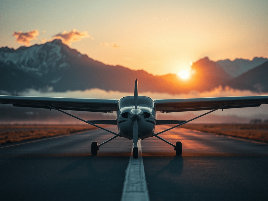
It was quite dark at the airport when we pushed the plane out and waited for that 30 minutes before sunup to depart. With the flight plan filed, we taxied out to depart on 16. When all the run-up checks were complete, the throttle was in for departure.
Stick forward, airspeed check, airspeed check… throttle to idle, shut down, jump out, pull the pitot cover off! Oopsy! Startup, run-up, throttle in, stick forward, airspeed check (much better this time around), rotate for a departure on 34. Great start to our adventure!
We contacted Calgary Terminal and received clearance to climb to 8500. We planned this trip a bit differently; we were going to follow the VFR route as much as we could. The winds were light and the weather was clear. We glided through the valley with no sign of a ripple in the air. The low sun reflected off the peaks creating brilliant colors. Quickly under our wings were Banff, Lake Louise, then Golden and Revelstoke – the only weather we saw was the usual fog in the Columbia Valley. The first stop was to be Kamloops, as there was a forecast for fog in the Vancouver area and we wanted to open up our options. As we passed through the Salmon Arm area, we pulled out the CFS to confirm fuel was available. It was noted that it only opened at 9:00 am local, so it was going to be a two-hour wait just to get fuel! I amended the flight plan for a diversion to Merritt. On our descent into Merritt, we could see some weather ahead down the Coquihalla and knew that the call to FSS would be interesting for filing the next leg to the Island. We filled up the plane and studied the maps to get a feel for the area. The weather report for Hope was not good, so going south was not an option. FSS was great in helping us through the area with a flight plan. We filed direct to Pemberton over the rocks and then down Howe Sound, as this was all open. It is amazing how close everything seems when flying!

We were soon crossing the Fraser Valley above many jagged peaks, then crossing the valley near Pemberton, then rounded the corner and there was Whistler. Wow – what a sight from the air! The Pacific soon was in view, but the Strait looked like it was closed in with fog. A call to FSS confirmed that the Island was open, but we would have to stay over the north end of Texada to stay clear of clouds. We amended the flight plan for that route, and we made a 60-degree turn to the west and over the last set of rocks to the Pacific.
Even these last sets of mountains had snow on top being so close to the warm ocean. The cumulus clouds hung off the mountains and towered all around well below us. It was an amazing array of colors with the white clouds and snow, green trees, and dark rock reflecting on the crystal blue water.
A very common occurrence on the coast is fog. On the day we were there, the fog was getting pushed in from a strong SW flow into all the valleys. The cloud came in just short of Pemberton and we were just north of it as we crossed all the valleys. It was neat to see all the valleys plugged from the air with all the peaks above the cloud top on each side of the valleys.
We soon descended into Qualicum Beach through a scattered layer. The mountains on the Island were covered in cloud, so we were concerned that our planned trip to Tofino might not happen. We filled the plane and parked it right beside a Turbine Beaver on amphibs. The plane sure looked tiny next to it! We got to talk with some great people around the airport. There was a guy in a Pacer who just filled up before us and was heading for Edmonton. He was happy to get a very current PIREP from us and he was on his way. We got talking to a Glasair builder about RVs. After talking a while, he commented that Van’s best design is the RV9. I quickly pointed out that this was an RV9 with the wheel where it should be, and he was pleasantly surprised. Not many RV9s with the wheel in the back, so he thought it was an RV7.
The airport restaurant only opened at 11:00 am, so we killed an hour walking around the airfield. Neglected aircraft are found everywhere, and Qualicum had its fair share. The air was hot and humid, which reminded me of home (New Brunswick). Soon the restaurant opened, and we made our way inside. We had a great meal and watched lots of aircraft activity at the airport.
We called FSS for a weather brief to see if Tofino was open. The fog was just on the beach and things seemed to be burning off, so we made our way. There were no PIREPs through the pass to get there, so we still did not know if the ceilings were high enough to get through. It was around 12:30 pm local and the air was still quite smooth at altitude. We soon flew over Sproat Lake and saw the big Martin Mars water bombers moored in the lake. A few minutes later, we rounded the corner in the pass to see clearing skies ahead – it was open, so flying through was easy. The scenery was the best we had seen, and we could hardly sit still!
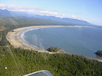
Everywhere we looked was beautiful. We called in over Kennedy Lake to Nanaimo Radio that looks after Tofino. We over-flew the airport for a quick view of the beach and touched down at the Tofino airport. We taxied to the south end of the airfield to be close to the road that went to the beach. After a bit of fence jumping and a short walk, miles of open beach surrounded us. Too bad for the freezing water as it would have been nice to go for a swim! We walked the beach and checked out the scenery. 😉 (Note from Jody: Aha! Now I know why I wasn’t invited.) After such a stressful day, we decided that getting back to the plane and flying somewhere for food would be a great idea. Destination – Chilliwack for pie!
On our walk back to the airplane, we met up with a couple from California. They were quite ecstatic about the scenery and how much fun they were having hopping from island to island. They became known as “American 182” because of the several mistakes that they made while flying in the area. That is a whole other story to tell!
We filed out of Tofino and we were on our way across the island. The ceiling had risen a bit more that afternoon as we cruised through the passes and valleys. What incredible scenery. It was 3:30 pm and Garret was impressed by himself for not being too bothered by the afternoon turbulence from the mountains. I have to say that, for the type of terrain, the air was very smooth. We were soon over Sproat Lake again and started to climb to 7500 to cross the Strait. The clouds stopped just after the mountain range, so we had no trouble getting high. We soon contacted Victoria Terminal, and they held our hand and passed us onto the Vancouver terminal. (I was sure glad we had shorts on just in case we had to go for a swim.) At 7500 ft, we remained within glide of land, but it still is a different feeling crossing water.
On the VFR Terminal charts, there are several routes to choose from. We chose the north route and flew over Horseshoe Bay and north of Vancouver. As we approached Vancouver, the haze was quite predominant, and we were soon over a scattered layer getting into more and more mucky weather. The forecast in Chilliwack was 15 gusting to 20 out of the SW and we were bucking a headwind all the way up the valley. There was clearly going to be a wind shear layer at some elevation as the haze was thick below the cloud base. We soon got permission to descend to stay clear of clouds as things looked to be closing in up front. We descended through the scattered layer and the turbulence started with a great tailwind! We over-flew Chilliwack and set up for the downwind.
There was a fair bit of stick action to keep the plane on track so I knew the landing would be interesting. Final was really gusty and about 60 degrees across the runway. The RVs can make anyone look good and the landing was uneventful. We were soon at corn level and the wheels touched for the completion of the fourth leg of the day. We taxied up to the pumps and it was Garret’s turn to pay. After the plane was full, we tied it down while we went in for supper. Life just doesn’t get any better!
We ordered up the main course and soon realized that going for a walk was required to make room for the pie. We walked around the airport to see what we could find. No matter how nice of an airport you go to, there are always many neglected aircraft. This is a real shame, but it is what it is. Once we felt there was room for the pie, we headed back to the restaurant. We kept trying to decide whether or not to make a fifth leg for the day. Over pie, we talked about Nelson for the night, but the weather did not look that great to the east. I remember the last leg until dusk over Ontario last summer; I just about got to the point where I wished I was on the ground, so the decision was made to not push it. A short 4-block walk to the motel and we crashed for the night. The plan was for an early start.
We had experienced fog in the morning when we arrived in the Vancouver area, so we were really concerned about fog the next day. There was a good chance that the weather would be the same. We had an early rise, and I made a quick call to FSS. It was clear where we were and FSS said that it was supposed to get foggy later in the morning but there were no signs of it yet. I made a quick call to Jody to find out when sunrise was in Chilliwack, and we soon found out that it was less than an hour away! Minutes later we were out the door, and I was filing on the walk. The weather looked great, so we did not want to get closed in with fog if we planned to get back home at a decent time. We packed the plane and made a thorough walk-around and we jumped in. There were no PIREPs in the area that early, so we knew we would be the ones to give the PIREPs for the areas with no current weather. We filed to Kamloops via the Coquihalla and then the VFR route back to Calgary. The ceilings in Hope did not sound like they were high enough for that route, but we could change in the air if we had to. Weather through Kamloops had some light rain showers with a high ceiling and was clear until about Golden. We did not know if we could get out of the rock as there was a very unstable air mass building on the Rockies moving east. Fog was also predicted in many of the valleys, so some decision-making on route was going to take place to keep the flight safe.
We were wheels up just before 7:00 am Calgary time under clear skies and on our way. There was some very light wispy fog near the river, but otherwise good to go. Just outside of Hope, the clouds started, and the ceiling was not high enough to make it through the Coquihalla, so we amended the flight plan to go up the Fraser Valley. A quick look at the terrain awareness and the pass up the Coquihalla went to total red. It is very easy to make quick decisions with this feature. It still was not that bright out and it was quite mucky throughout the area. There is so much moisture in the air out there, making this a common occurrence. FSS assured us of improving weather ahead but could not verify the condition up the trench. We slowed things down and paid close attention to the weather ahead. The trench is the safest route as there is no pass to cross heading north to Kamloops. Things never got worse, and we always had an out to turn around. It wasn’t long after that that things got brighter ahead so we knew it was soon time to climb and get the shades on. We cleared the cloud just before the turn to Kamloops and we had the first hurdle taken care of. I called FSS to give a PIREP so others knew the trench was VFR.

A few spits of rain hit the windshield through the Kamloops area as forecasted. Since there was forecasted fog for Revelstoke and Golden, we had to decide to top the fuel up just in case we could not get out of the mountains and had to divert all the way back to Salmon Arm. A quick call to FSS and they pulled up real-time pictures of both Revelstoke and Golden. He could not see any fog, so we decided to keep going as there were no issues getting back to Golden if we had to. Garret wasn’t so sure about his bladder, but I motivated him by telling him he could do it and we were halfway home. (Note from Jody: This is my concern about flying ‘long haul’ with Troy once the RV10 is built. There will be no ‘holding it’ for me or the kids, mister!) We were soon over Revelstoke and into the Rogers Pass with no bumps in sight. We cleared the glacier and headed direct to Golden.
The Columbia Valley was also clear, but the weather ahead did not look that great. We could see the buildup everywhere to the east. We tried FSS in Golden but could not get a response. A Buffalo was flying up near Edson (that sounds funny), and he got a weather relay out of Edmonton for us. (It is nice to know that there is always someone out there to help out.) He basically said that it did not look good – marginal VFR at best. It was unknown at the time if we could get through, so we plugged along to have a look. The weather was still quite good until Banff; the ceiling kept coming down after Lake Louise, but the visibility was still good. I tried FSS once more just to see if there were any updates or PIREPs through the Canmore area. I was getting down on fuel, weather was bad, and FSS was downright rude. They were of no help because they were mad that I just got an update 20 minutes ago and was looking for another one so soon. This was the only time on a XC that help from FSS was important to have and they made me feel like I was wasting their time.
Once we rounded the corner in Banff, we really did not think we would get out. I dropped down in the middle of the valley to stay clear of the muck. The last corner at Exshaw would confirm if we could get out or not. We still had good visibility on the north side of the valley, and it looked like we would make it staying close to the river. The highway was closed in by weather as it went into higher terrain. By this time, we were in heavy rain but in contact with Springbank. They assured us that it kept improving as we headed east. Weather was manageable, so we knew we had it beat. We never got much below 1000 ft, so at no point were our decisions out of line and terrain awareness was being well used. Springbank soon asked us if we could climb higher to clear traffic; by that time, we could and tucked under the base at 6000 ft. We got transferred to Calgary Tower and crossed the middle of the city.
The rain stopped just east of downtown, and we started our descent into Chestermere, not before making a quick pass over the house letting the family know we were home. We touched down just less than three hours from Chilliwack, including the XC to Langdon and back to the field! 9:50 am Calgary time and the day was just getting started – it was time to get the floors done so I could order the new RV10 to bring the family along to enjoy this great rewarding hobby.
