We had the fuel tanks topped-up and checked the radar on the Internet. There were three thunderstorm lines developing quickly in our path, so we decided it was better to wait awhile. It was only just after lunch local time – so we had been making great time! Lots of floatplanes flew in from the West where the weather was good. At no point did we get bored.
As time went on and the weather did not improve to the Southeast, I knew I had to come up with another plan to make some headway. The radar showed all the weather activity to the South, so if we headed Northeast around Nipigon Lake, Ontario, we would have a lot less rain to deal with. At approximately 5:00 p.m. local time, we were wheels-up again heading to the middle of nowhere. At least we were heading in the right direction and clear of major thunderstorms.
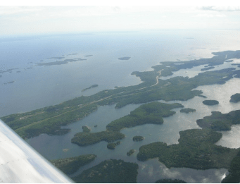
The only real navigation we had to use was a rail spur that we could see. Global Positioning Systems are great, and we had the AvMap and two spares on board in case we screwed up – it sure feels good to know exactly where you are on the map at all times! Nipigon Lake soon came into view, and we cut the corner off of it to make our way down to Geraldton, Ontario. (We had no place to land anyway!) The only sign of civilization was the odd floatplane tied to a dock by a cottage. What a great getaway retreat!
The touchdown in Geraldton was non-eventful until Garrett asked me if I had spotted the deer on the runway. I saw what we thought was a deer and slowed down well before it. It turned out it was a deer with two legs, and they call them cranes in Ontario. It just watched us taxi by with not a care in the world.
It was finally time for me to introduce Garrett to the notorious Black Fly! He was glad I had told him to buy a screen jacket because did we ever need it! Clouds of them everywhere!
Our arrival was a bit late, so we knew there would be a callout charge to get fuel. I called Flight Services to get a weather forecast and was informed there was a 30% chance of fog in the morning, so a 70% chance of none. We dug out the extra 100 bucks for the callout so the plane would be ready for a 6:00 a.m. departure. Six o’clock a.m. came, and Lady Luck was not on our side. We could not even see the runway that was 500 feet away! We went back to sleep and only achieved wheels-up at 9:00 a.m. local time. We climbed through a thin scattered layer, and it was soon cloudless skies. As we looked back, the clouds stopped right at Geraldton. A lesson learned about gambling!
Next stop was Rouyn-Noranda, Quebec. This would be a 2.5-hour leg following the highway through the Kapuskasing area. It was a smooth ride at 7,500 feet and not much wind, though we could see cloud cover several miles South of our route. The weather forecast for Sudbury South to the Toronto area called for heavy rain, so our Northerly route was the best decision. We soon reached the Quebec border and were greeted with a low scattered layer of cloud that was becoming broken. The decision was made to get under the cloud cover, which would give us a great look at the rugged country of Northwestern Quebec. By this time, we were hungry because we did not have much for breakfast. Water and snacks had been on the menu, and Garrett, and his empty stomach, did not enjoy the bumps we found under the clouds. If I had told him the leg was 2.5-hours before we left, he probably would have made me stop sooner… not that there were many choices!
When we landed in Rouyn-Noranda, fuel and food were our first priority. We realized that we were quite a distance from town, so finding food was going to be time-consuming. We asked the fuel truck driver where the nearest source of food was, and he pointed to the terminal building – we could not have been more excited! A Quebec greeting with the special of the day, which was Montreal Smoked Meat sandwiches with fries. A great empty stomach shocker! We were not in a rush to leave because we knew reaching Bathurst, New Brunswick would be easy, so we spent some time giving the aircraft a good thorough checkout because the next 2.5-hour leg was over nothing but bush and lakes. There is also what Easterners call ‘mountains’, but we only saw them as bumps compared to the Rockies!
I knew that Garrett was still not feeling 100% even after the great meal. On climb out, the air was quite rough and he did not look that comfortable. Being the considerate pilot that I am, I took us through the scattered layer to smooth air. The smooth ride brought a smile to his face, and he really thanked me. I will do whatever it takes to keep the cookies where they belong! Unfortunately, the scattered layer started to close in and we had to descend. The cloud base was around 5,500 feet, so we still had plenty of height to feel comfortable over such a rugged environment. The bumps settled down as the clouds turned into a solid overcast and light rain showers. The one thing that is nice about navigating in this part of the country is the power lines show up like a sore thumb compared to the prairie. You can spot intersection locations for miles. The only significant weather was one large cell brewing to the Southwest, but we stayed plenty clear.
The St. Lawrence soon came into view, and we were so glad to see civilization. The young lady on the Unicom was a “Jill” of all trades. She did the radio work, filled up the plane, closed our flight plan, got us weather, and took our money. Could not have been better service! We were so glad to be back in civilization because they had food at their airport too!
The last leg to Bathurst was all that was left. I made a last phone call home to my parents to give the latest ETA and to confirm that the seafood chowder was ready on the stove. The maps showed headwinds for most of the way, so I allowed for the extra time. We departed Trois-Rivières, Quebec for Bathurst, N.B. via Quebec City as the dogleg than direct from there at a point where we would miss the US border. Quebec terminal led us through their zone with some great views of the city. Once leaving the St. Lawrence, there was scattered civilization and then nothing for the last part of the trip near Mount Carleton in familiar territory. We climbed to 7,500 ft after leaving Quebec airspace and headed direct to Bathurst. Once we passed the St. John River Valley, it was not long until we could see the Bay of Chaleur coming into view. What a feeling it was. Mount Carleton, the highest point in NB, was well below us to the South and looked like a bunch of bumps from our 7500 perch.
It was around 8:00 pm local time, and the sky had a thin overcast just above us and not a bump in the air for the entire leg. At about 50 miles out, I decided to see if the Unicom operator was still there. Sure enough, we had a reply and a quick update on the weather. At that moment, I heard nothing; winds less than 5 knots is all I got. I was so excited my mind was somewhere else. I did not worry too much about it as we were a long way out and I would ask again as we got closer. The airport is very close to sea level, so I figured for something to do in the still air I would trim the plane out to commence with the long descent.
Soon after we heard “FTJE this Bathurst Unicom” “This is FTJE go ahead” “What is your latest ETA, your fan club is starting to build” “8 min 22, 21, 20, 19 seconds” I was ecstatic that we were so close to getting there! I decided this would be a good time for a wind update and I would listen to the direction this time. It was right across the runway and light so the choice was mine. I said to Garrett to listen to what I was going to say. “Bathurst Unicom this FTJE, we will proceed with a straight in on 10 with a low and over high speed for our arrival if you will accept” “There is no reported traffic in the area, the airport is all yours” “FTJE will report 5 miles back for straight in on 10 low and over.”
I turned on the navigation and landing lights, we were ready. At five miles back, I called in and reported just over two minutes until arrival. We screamed down the runway at nearly 200 miles an hour and pulled into a gentle climbing left turn for the circuit. We could see many people on the ramp waving and flashes going off as we went by- what a feeling! On the climb, my engine monitor warning went off flashing 14. I pulled the power back and it quickly went away. It was not until the next day that I realized my flow limit is set to 14 gallons per hour. Full throttle and full rich at sea level is something the engine had not experienced before – all the ponies were getting used! After we landed, my grandfather said, “We could see the lights coming from a long way away and it looked like a pretty big plane; then you zoomed down the runway in this little thing, I couldn’t believe it!”
The last challenge was still left – not to bounce the plane in front of my family! We came over the fence with the numbers on target and chirped the wheels onto the runway. When you spend two days flying steady, landings keep getting easier. We taxied up to the ramp and were greeted by my parents and grandparents. The trip, and the dream, was complete. We unloaded the plane and rushed home for the great seafood chowder waiting on the stove!
