
Now that I have over 50 trouble-free hours on the RV10 we have been trying to plan a larger trip for some time. The weather just never seems to cooperate for a flight to the west coast which is where we wanted to go. Lucky for us, on Tuesday (May 19, 2009) we made a decision to fly out to the west coast on Thursday as the weather was showing a big ridge of high pressure moving into BC and Alberta. There are very few times that you get perfect weather all the way through the mountains, which lasts for several days. If we were lucky, this could be one of those times.
On Thursday we did our best to get up and away early. With two munchkins, all bets are off to be in the air early. I got up at 5:30 and we still only made it to wheels up around 9:45. I guess it is not that bad considering we have an hour drive to the airport and had to pack the plane. With the flight plan filed and the spot tracker turned on we were on our way. The back track on 24 at High River had to be shortened as a Cessna driver was not listening to his radio and made a really short down wind and turned final when I was still on the back track. I noticed him on downwind when we entered the active, he did not respond to me asking him to extend so I would have more time. A quick turnaround and we were out of there.

We had filed direct to Kimberley and then out the pass at Crawford Bay. Once level at 12,500, it was clear that the scattered forecast was overcast and there was no way to remain legal without a VFR over the top filed. A quick look at the weather on the 496 and sure enough Cranbrook was scattered so I could have gotten down. To be safe and by the rules I turned south and gradually descended to find a gap in the clouds and the rocks to be able to make our way west. I amended my flight plan from the air, and we were on our way. We were grounding at 185 kts going south so the deviation would not add that much time.
Once we were west of Sparwood the clouds opened up and we climbed up to 8500’ and were able to stay there for the rest of the trip. I ran 50 rich of peak (ROP), truing out at 170+ kts with about 10 to 15 kts on the nose burning 12.5 GPH. We soon passed Nelson, then Castlegar, Oliver, Penticton and so on. We were filed pretty much direct from Nelson as the weather allowed it. As you get closer to the coastal range, the mountains get higher again and the valleys very small. It was very desolate south of Princeton, so I gave many position reports along the way to make it easier to find us!!
The small valleys were close together near Hope, so I just kept on plugging away direct and jumped from one valley to the other. I cleared the last set of rocks just west and south of Hope and started our descent. Now I had to try to get to down to 1000ft circuit height in Chilliwack in a very short time. With the power pulled back and the prop set to fine pitch while watching cooling rates, we made a fast descent into the big valley. Sure enough, I was too high and made a wide turn from the north to lose the last bit of altitude. The cabin filled with moist air and the temperature went from -4°C to +18°C. We turned final and touched down 2.5 hours after takeoff. We filled the plane up (115 litres) and went into the terminal for lunch. There was lots of activity at the airport keeping everyone occupied while we ate. I had many people ask questions about the airplane. Everyone was very interested in the plane’s numbers.

After a couple of hours there, we filed for our final destination, Qualicum Beach on Vancouver Island. This would be my first takeoff from sea level to see how much power this plane did have. The engine pushed us all back in our seats and we were soon airborne burning 24 GPH in the climb. I pulled the power back to 25 and went into cruise climb mode. The throttle had to be pulled a long way back to get that power setting. I contacted Vancouver terminal and were cleared to climb to 4500’. Once level we had to descend to 4000’ to get clear of an Air Canada flight that passed nice and close above and just ahead of us (yes, I could read Air Canada on the jet). After that we got cleared to climb to 6500’ for the remainder of the flight. We flew north of Vancouver and up the Sunshine coast past Seachelt and then jumped over the south end of Texada and started our descent into Qualicum. We checked out the beaches from the air and then set up for the approach. 30 min from takeoff we were on the ground in Qualicum.
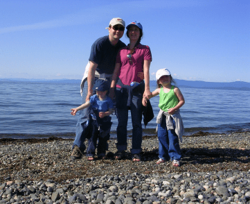
Once we got everything unloaded and tied down, we called a cab to bring us to the Hotel. We soon unpacked what we needed and walked over to the beach. The kids played for a while and then we had some supper. The next day we rented a car and toured around the area and out to Port Alberni and Parksville. We spent time on the beach and walking through the large old growth forests. There was so much to see so we know we have to go back a few more times this summer.
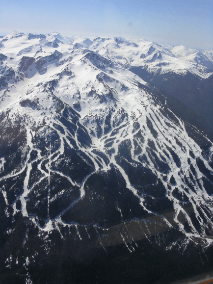
Saturday morning, we got the car back and the plane ready to go. By 10:40 Calgary time, we were wheels up in clear skies. Once I climbed through 1300’, I started my right turn over the water towards Howe Sound. The climb rate is so high that I would always be in gliding range of land if something really bad happened. It is a bit of a different feeling flying over water if you do not do it all the time. I soon contacted Vancouver Terminal for clearance to 7500’. That was approved and I set a slow cruise climb of 500 ft/min with the autopilot and enjoyed the scenery. There was not a ripple in the air as we cruised above the snowcapped peaks.
Once we passed Whistler, I made the last climb to 9500’ for the remainder of the flight. Once I got there, I decided to make my first cross country running lean of peak (LOP). I turned the peak detection on and gradually pulled the mixture back. I was down to about 19 inches of manifold pressure and the throttle was back about 25% from full. I was in the 55% power range. The EFIS shows all 6 cylinders as they are on the engine and when “Peak Detection” mode is on, the top number is the peak EGT, and the bottom number is the EGT at that time. As you lean, the fuel flow keeps coming down and the EGT keeps going up. Once the EGT has peaked and you keep leaning the fuel flow will still keep coming down and the EGT will come down as well. Another number will appear with an L after it to show how far lean of peak you are. If you richen the mixture past the peak and the flow goes up, you will get an R to show how much rich of peak you are… nice and simple. EGT and fuel flow is how it works.
So, I leaned to around 25° to 50° LOP range. You don’t want to go more that 50° LOP. Some engines will get rough near 50° but this engine is smooth way past that. So, I must use the number as there is no change in sound or smoothness. The other item you need to look at is airspeed. That will decay as you run LOP. So, you have to decide what to trade off: speed or fuel burn. The fuel burn came down to about 10.3 and the airspeed lost about 10kts. This set up would give me a no wind range of about 1165 NM. As I go higher, these numbers will get even better.
This is about the lowest altitude for best LOP operation.
So, with everyone either sleeping, reading or eating crackers, we plugged away with a ground speed of 170kts all the way home. Lots of leg room, comfy seats, plenty of music choices and a way better view than WestJet. I just had to turn the autopilot track a few times to make sure I missed the mountains. The system would screech at me that there was terrain ahead and to pull up if I got to close. Once we rounded the corner at Rogers pass the bumps started. It was afternoon flying in the mountains, so it was a given. If the bumps got too bad, I would shut the autopilot off as it would get the plane flying to fast when we hit strong updrafts. It sure knows how to hold altitude!! It is not safe to be truing out at 185 kts in turbulent air high in the mountains when you don’t know how big the next hit is going to be. The autopilot will shut off after a certain speed to prevent an overspeed condition. As soon as we cleared the rocks after Canmore, I made a direct leg to High River. We touched down in High River exactly 3 hours later nonstop. The trip was 485 NM or 900 km by air one way. We burnt 34 gal to get back. The climb used lots of gas giving and an average of 11.3 gph or so for the trip. It was probably closer to 11 as the 34 gal included the warmup time and taxi. This plane will drink gas just at idle too, so start it and get going is the best advice.
All and all it was a great trip. MapQuest says this trip would take 15 hours and 38 minutes to drive and that does not include the ferry wait and crossing time. I guess we would have had to turn around when we got there to make it back in the same time if we drove! I can’t wait for the next trip as I just got my four-place oxygen system! Now we can stay out of the bumps the whole way no matter what time of day it is.
The kids did really well for the first big trip. Emma is a pro as she has been flying with me for three years and has over 40 hours airtime and she is only four and a half years old. Gavin is well on his way to building hours and gets really excited to go flying. He even yelled out “High River” when we got back… pretty impressive for a two-and-a-half-year-old after a three-hour flight over terrain he had never seen before. Jody is looking forward to the day that we can have both kids together in the back seat. I look forward to that day too.
